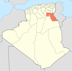
El Oued Province ولاية الوادي | |
|---|---|
 Map of Algeria highlighting El Oued | |
| Country | |
| Capital | El Oued |
| Area | |
| • Total | 54,573 km2 (21,071 sq mi) |
| Population (2008)[1] | |
| • Total | 673,934 |
| • Density | 12/km2 (32/sq mi) |
| Time zone | UTC+01 (CET) |
| Area Code | +213 (0) 32 |
| ISO 3166 code | DZ-39 |
| Districts | 12 |
| Municipalities | 30 |
El Oued (Arabic: ولاية الوادي) is a Saharan province of Algeria (n° 39) dominated by Oued Souf. It was named after its eponymous capital. Notable towns include El Oued itself and Guemar, Debila, and Robbah.
Administrative division
The province is made up of 12 districts, which are divided into 30 communes or municipalities.
Districts
Communes
References
- ↑ Office National des Statistiques, Recensement General de la Population et de l’Habitat 2008 Preliminary results of the 2008 population census. Accessed on 2008-07-02.
External links
Lua error in package.lua at line 80: module 'strict' not found. Lua error in package.lua at line 80: module 'strict' not found.
| This article about a location in El Oued Province is a stub. You can help Wikipedia by expanding it. |
ar:ولاية الوادي de:El Oued (Provinz) es:Provincia de El Oued fr:Wilaya d'El Oued gl:Provincia de El Oued it:Provincia di El Oued sw:Jimbo ya El Oued (Aljeria) lad:Wilaya de El Wed lt:Uedo vilaja nl:El Oued (provincie) no:El Oued (provins) pl:Prowincja Al-Wadi ro:Provincia El Oued ru:Эль-Уэд (провинция) sv:El Oued (provins) tg:Вилояти Ал-Водӣ tr:El Vadi Vilayeti ur:صوبہ الوادی vi:El Oued (tỉnh) war:El Oued (lalawigan) zh:瓦迪省